By Kyle Ulmer · · 12 min read
The short version: ultrasonic is the budget pick for small, clean bins and tanks. Radar is the workhorse for tall, dusty silos where you need a live reading. LiDAR is what you reach for when you need the shape of the material, not just one distance: open stockpiles, storage buildings, bunkers and big silos where a single reading can't tell you what's really in there. Read on for the why.
In this article
How each sensor measures distance
Every non-contact level sensor works the same way at heart. It's called time of flight: fire off a pulse, wait for the echo, and time the round trip. Half that time multiplied by the pulse's speed gives you the distance. Subtract it from the height of the vessel and there's your level.
What changes is what the pulse is made of:
- Ultrasonic sensors use a burst of high-pitched sound.
- Radar sensors use microwaves. Most modern non-contact units are FMCW radar (frequency-modulated continuous wave), usually around 80 GHz.
- LiDAR sensors use pulses of laser light.
That one choice ends up deciding almost everything else: how wide the beam is, what gets in its way, how far it reaches and what it costs.
Level isn't volume: the single-point problem
Most ultrasonic and radar sensors (and plenty of simple laser ones) give you one distance to one spot. To turn that into inventory, the software has to guess what the rest of the surface looks like. Usually it assumes it's flat, or a cone at some set angle.
Bulk solids don't play along. Material heaps up into a cone under the fill point, sinks into a funnel over the outlet, sticks to the walls and slumps unevenly when you fill from one side and pull from the other. Liquids level themselves out. Powders, grains and aggregates don't.
Let's run the numbers: one reading in a cement silo
Picture a 20 ft diameter silo full of portland cement, which weighs about 94 lb/ft³. Say the cement has piled into a cone under the fill point with a 30° slope. (Real angles depend on the material and conditions; 30° just keeps the math simple.)
- From edge to peak, that cone rises about 5.8 ft (10 ft radius × tan 30°).
- A sensor aimed at the center sees the peak. If the software thinks the surface is flat, it counts a full 20 ft wide cylinder, 5.8 ft deep, where there's really just a cone.
- The cone holds about 605 ft³. The flat cylinder the software imagined holds about 1,815 ft³.
- So you're counting roughly 1,210 ft³, or about 57 tons of cement, that isn't there.
When you draw the silo down, it flips the other way: a funnel over the outlet makes a center reading come in too low. Mounting the sensor off-center and entering a cone angle helps, and any decent vendor supports both. But it's still a guess, and the guess falls apart as soon as the surface stops cooperating.
That's why "which sensor is most accurate?" is the wrong question. A radar can nail the distance to one point and still hand you the wrong inventory. The better question is: can one point stand in for this whole surface?
In a small bin with a steep cone bottom, it usually can. In a flat storage building, a covered bay or an open yard with a few piles, no chance. You need the whole surface measured, and that's what scanning LiDAR does. (There are multi-point acoustic "3D" scanners too. They sample a handful of points and fill in the gaps, which puts them somewhere between one reading and a full scan.)
Ultrasonic level sensors
How they work. A transducer chirps out a burst of sound, way above what you can hear, and listens for the echo. The speed of sound changes with temperature, so most units have a built-in temperature sensor to correct for it.
What they're good at
- They're the cheapest non-contact option, and easy to install and set up.
- They have a long track record on liquids and on small bins, hoppers and day tanks.
- Nothing touches the material, so there's not much to wear out.
Where they struggle
- Dust soaks up sound. A heavy dust cloud during filling weakens or scatters the echo, and fluffy powders don't bounce much back to begin with.
- Temperature, vapor and air currents all change the speed of sound. The compensation fixes the average, not the temperature layers inside a tall vessel.
- The beam is fairly wide, so it can catch false echoes off ladders, braces and buildup on the walls. Sloped surfaces can also bounce the echo away from the sensor.
- There's a blind spot (the dead band) right in front of the transducer, which bites you when the vessel is nearly full.
- Range on bulk solids is usually shorter than on liquids.
- It's one point, so it runs straight into the single-point problem above.
Best for: liquids, and small, clean bins and hoppers where cost matters and the surface behaves.
Radar level sensors
How they work. The sensor sends out microwaves and measures what comes back. FMCW radar sweeps its frequency continuously and works out distance from the difference between what it's sending and what it's hearing back. Higher frequencies like 80 GHz squeeze a narrow beam out of a small antenna. (Guided-wave radar, which runs the signal down a cable or rod into the material, is a different, contact-based animal.)
What they're good at
- They see right through dust. Microwaves don't care about airborne dust, so radar keeps reading even while a silo is being blown full. For solids, that's its superpower.
- Temperature, pressure and vapor don't throw it off the way they do sound.
- A narrow 80 GHz beam dodges most of the stuff inside a silo, and the long range suits tall ones.
- You get a continuous reading every few seconds that plugs straight into a PLC or SCADA system.
Where they struggle
- Materials with a low dielectric constant (some plastics, powders and dry grains) don't reflect microwaves well. Newer high-frequency sensors handle this much better than older ones, but it's worth asking the vendor.
- They cost more per point than ultrasonic.
- They're still one point for most units, so volume in a silo with cones, funnels or wall buildup still comes down to a guessed surface.
Best for: continuous level in tall, enclosed, dusty silos, where the reading has to keep updating during filling and feed your plant automation.
LiDAR level and volume sensors
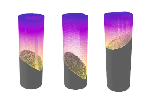
How they work. A laser rangefinder times a pulse of light. On its own, that's just another single-point distance sensor, and single-point laser level sensors are out there. A scanning LiDAR sensor goes further: it spins the rangefinder around and records which way it was pointing for every reading, so each one becomes a point in 3D space. Stack up thousands of them and you get a point cloud, a model of the material surface, the floor and the walls. Volume then comes from the surface you actually measured, not one you assumed. Our technology overview walks through it step by step.
What they're good at
- They measure the whole surface. Cones, funnels, ridges, several piles and the gaps between them all get measured, not guessed. This is the fix for the single-point problem.
- The beam is very narrow, so you get fine detail and every point lands exactly where it should.
- They reach far and cover a lot. One scanner can cover a whole building or a chunk of a yard, and you can stitch scans from several sensors together for big sites.
- You get receipts. Every scan is a 3D model you can look at, re-measure and compare over time, not just a number on a screen.
- It brings its own light, so it works the same at noon, at midnight and in a dark storage shed.
Where they struggle
- Light can't punch through heavy dust, steam or fog like microwaves can. Scan a silo mid-fill and you'll get a lovely 3D model of the dust cloud, not the material. Scans have to run when the air is reasonably clear. Scheduling makes that easy, but it also means LiDAR isn't going to replace radar for fill control.
- The optical window has to stay reasonably clean.
- Very dark or wet surfaces bounce back less light, which cuts the usable range.
- A scanning sensor takes minutes, not seconds, to build a full point cloud. That's fine for inventory, and not what you want guarding against overfills.
Best for: volume and tonnage on anything lumpy: open and covered stockpiles, storage buildings and domes, commodity bays, bunkers, and silos too wide or too uneven to trust one reading.
Our experiment: a LiDAR silo scanner with a purge air knife
We wanted to find out if a permanently mounted LiDAR scanner could survive life inside a busy, dusty silo. There are two problems: dust in the air blocks the beam during a scan, and dust that settles on the window makes every scan after that worse. So we built a LiDAR test unit with a purge air knife. That's a narrow slot that turns an air supply into a thin, fast sheet blowing across the window. It keeps a curtain of clean air between the glass and the dusty air, so particles get swept away before they can land.
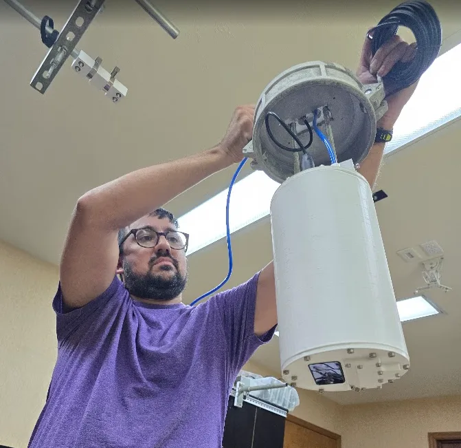
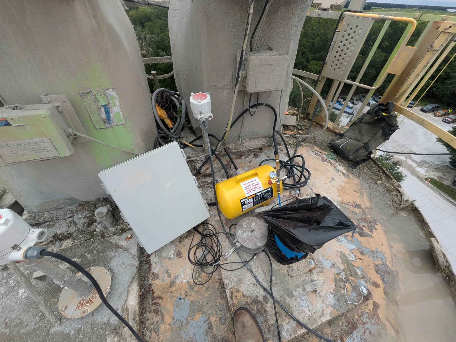
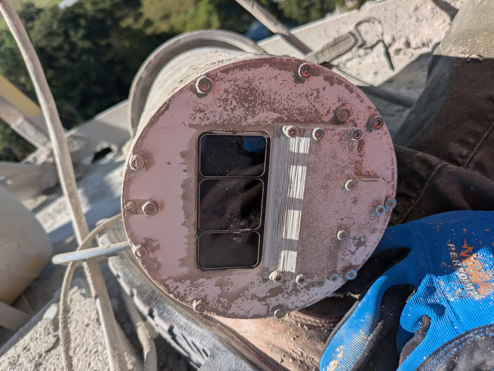
We put the test unit in two silos, one full of fly ash and one full of cement. Both are fine, light powders, and both silos vent through a baghouse dust collector.
What happened. While the plant was running, the baghouse kept the air in the silo headspace so stirred up that the scanner couldn't get a usable look at the material. A spotless window doesn't help much when the air in front of it is full of dust. Overnight, with the facility shut down, the dust settled and the air cleared up enough for the scanner to do its job.
What we took away. It backed up exactly what this article says: an active, dusty silo isn't the place for continuous LiDAR monitoring. For a live level reading in silos like these, radar is the better tool. LiDAR still earns its spot there as a periodic 3D audit, scheduled for quiet periods once the air has cleared. A full scan then shows the cones, funnels and wall buildup a single-point sensor can't.
Where the EOS2 fits
The EOS2 is our scanning LiDAR sensor. It sweeps a full 360° × 180° sphere in about three minutes at 1° resolution, reaches 100–200 ft in every direction depending on the material, and sips little enough power to run on solar. Mount it permanently over your stockpiles and it feeds Hyperion, which turns each scan into a quality-checked volume and tonnage on whatever schedule you like. At a cement plant in Newberry, FL, four EOS2 scanners measured an indoor coal pile to within 0.55% of a certified terrestrial survey.
In silos we use the EOS2 a bit differently: as a periodic 3D audit, lowered through the roof hatch while the silo is quiet. It shows you the real surface, the wall buildup and any rat-holing. For a continuous, second-by-second level in a dusty silo, we'd honestly point you to a radar. The two work great together.
Here's what one of those audits looks like: a raw EOS2 scan from inside a silo, colored by height. Spin it around and zoom in to see the cone, the walls and the roof structure a single-point sensor never sees.
Loading 3D model…
Side-by-side comparison
| Factor | Ultrasonic | Radar (non-contact) | Scanning LiDAR |
|---|---|---|---|
| Signal | Sound | Microwaves (commonly ~80 GHz FMCW) | Laser light |
| What it measures | One distance | One distance | The full 3D surface (point cloud) |
| Volume | Calculated from an assumed surface shape | Calculated from an assumed surface shape | Calculated from the measured surface |
| Airborne dust | Weakens the echo | Largely unaffected | Blocks the beam; scan when the air is clear |
| Temperature and vapor | Affect the speed of sound; needs compensation | Largely unaffected | Steam and fog block the beam |
| Beam | Relatively wide | Narrow at high frequency | Very narrow |
| Update rate | Seconds | Seconds | Minutes per full scan |
| Coverage per sensor | One spot | One spot | A whole building or yard section |
| Relative cost per sensor | Low | Medium to high | Medium; the EOS2 is $2,750 or $100/month |
| Best fit | Liquids, small clean bins | Continuous level in tall, dusty silos | Stockpiles, buildings, bays and uneven surfaces |
So which one should you pick?
Start with what you need the number for. Then look at the surface and the air.
- Are you trying to prevent overfills or run automation in real time? Then you need a fast, continuous reading. In a dusty silo, that's radar. In a clean bin or tank, ultrasonic might be all you need.
- Are you after inventory: volume, tonnage, month-end numbers? Ask yourself whether one point can stand in for the whole surface. In a narrow vessel with a steep cone bottom, a well set-up point sensor can do it. If your material lives in open piles, bays, buildings or wide silos, you need the surface measured, and that means scanning LiDAR.
- Is the air clear at least some of the time? LiDAR needs a clear view, but only while it's scanning. Most stockpile yards and storage buildings have plenty of quiet time to schedule scans into.
- When the numbers don't match, can you see why? When a point sensor and the books disagree, all you've got is a number. A point cloud shows you exactly where the material is, which makes those arguments a lot shorter.
Lots of sites end up with both: radar on the silos for process control, and LiDAR over the stockpiles and storage buildings for inventory. The point isn't to crown one technology for everything. It's to stop trusting a guessed surface when the number actually matters.
Not sure what fits your site?
Send us a photo or a quick sketch of what you store and how you store it. We'll tell you straight whether LiDAR is the right tool, and if it isn't, what we'd use instead. Ask an engineer.
Frequently asked questions
Is radar more accurate than ultrasonic for silo level?
For bulk solids in dusty silos, usually, yes. Dust, temperature and vapor barely bother radar, and high-frequency radar has a narrower beam that dodges false echoes. Both still measure a single point, though, so your volume is only as good as the assumed surface shape.
Can LiDAR measure level through dust?
Not reliably. Heavy dust, steam and fog scatter laser light, so LiDAR scans should run when the air is reasonably clear. For inventory that's rarely a problem, since you can schedule scans for quiet periods. For a live level reading during pneumatic filling, go with radar.
Why does my level sensor disagree with my inventory records?
Often it's because a single-point sensor turns one distance into a volume by guessing the surface shape. A cone under the fill point, a funnel over the outlet or material stuck to the walls all throw that guess off. Book inventory has its own scale and moisture errors too. A 3D scan of the real surface is the fastest way to find out which number is wrong.
What is the difference between a 3D level scanner and a scanning LiDAR sensor?
"3D level scanner" often means a multi-point acoustic device, which samples a few points in a silo and fills in a surface between them. A scanning LiDAR sensor measures thousands of points with a narrow laser beam and builds a dense point cloud of the whole surface, floor and walls.
How much does a LiDAR stockpile monitoring system cost?
The EOS2 LiDAR sensor is $2,750 to buy or $100 a month to lease, and Hyperion software plans start at $100 per facility per month. How many sensors you need depends on the size and layout of your site. Check out EOS2 pricing or ask us for a site review.
Related reading
- How LiDAR stockpile measurement works: from laser pulse to point cloud to quality-checked tonnage.
- Silo inventory scanning with the EOS2: a full 3D audit of a silo, lowered through the roof hatch.
- Case study: 0.55% vs. a certified survey: four EOS2 scanners measuring an indoor coal pile at a cement plant.
Comments
No comments yet. Questions and field experience are welcome.
Leave a comment