By Kyle Ulmer · · 8 min read
The short version: every scanner sees the world from where it's standing, so its point cloud is in its own coordinate system. Registration is how you line all of those clouds up into one model. You can do it against a drone survey of the site, against satellite imagery, against the overlap between the scanners themselves, or, indoors, against the building. Here's how each one works and when to use it.
In this article
What is point cloud registration?
A LiDAR scanner measures everything relative to itself. To the scanner, it's always sitting at the center of the universe, pointing "forward." So if you mount three scanners around a yard, you get three point clouds that each think they're at 0, 0, 0. Drop them into the same file and you get a jumbled mess of overlapping piles pointing in different directions.
Registration is the process of finding how to move and rotate each cloud so they all land in one shared coordinate system and line up with each other. For fixed scanners that's a rigid transform: a rotation plus a shift, with six numbers per scanner (three for position, three for orientation). Nothing gets stretched or warped. Each cloud just gets picked up and set down in the right spot.
It usually happens in two steps:
- Coarse alignment gets each cloud roughly in place. That can come from a known mounting position, a GPS fix, a few matched points picked by hand, or a reference like a drone survey or satellite image.
- Fine alignment takes it the rest of the way. Algorithms like ICP (iterative closest point) nudge the cloud around until the surfaces it shares with the reference sit right on top of each other.
Fine alignment is great at polishing, but it needs a decent starting guess. Start it too far off and it can happily lock onto the wrong wall. That's why the coarse step matters so much, and why most of the techniques below are really about getting a good, trustworthy starting point.
The good news for permanent installations: the scanners don't move. Once each one is registered, the same transform applies to every scan it takes from then on. You do the careful work once at install, and every hourly or daily scan after that lands in the right place automatically.
Outdoors: register to a drone survey
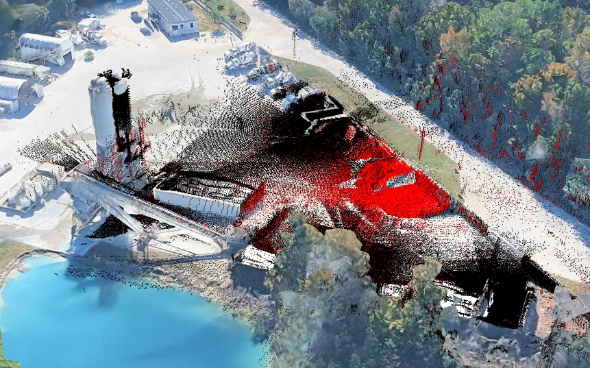
For an open yard, a drone is a fantastic registration tool. A drone flight (photogrammetry or drone LiDAR) captures the whole site from above in one go: every pile, wall, road edge and building in a single, consistent model. If the flight uses ground control points or RTK positioning, that model is also tied to real-world coordinates.
The trick is to run the fixed scanners at the same time as the drone flight. Stockpiles change all day long, so if the drone flies in the morning and the scanners run in the afternoon, the piles won't match and they make lousy alignment targets. Scan at the same time and every surface in the scanner clouds has a twin in the drone model.
From there, each scanner's cloud gets registered to the drone model on its own:
- Rough it into place using the scanner's known mounting location, or by picking a few matching features like a wall corner or a pole.
- Run fine alignment against the drone model, favoring things that don't move: walls, lock blocks, curbs, building faces and the ground around the piles.
- Check the fit, lock in the transform, and move on to the next scanner.
Because every scanner is registered to the same reference, they all end up consistent with each other too, even scanners that can't see any of the same ground. And the drone flight doubles as a sanity check: you can compare the scanner-based volumes against the drone volumes from the same moment.
Why not just use the drone for everything?
You could, but someone has to fly it, and you only get numbers when they do. Fixed scanners measure hourly or daily with nobody on site, including at night and in weather you wouldn't fly in. The drone is the perfect one-time reference. The scanners do the day-to-day work.
Use satellite tiles when your sensors are georeferenced
No drone? If your scanners can be geospatially referenced (their positions surveyed or taken from GPS, plus a known heading), satellite imagery makes a surprisingly handy alignment tool.
The idea is to put each scanner's cloud onto a satellite map tile of the site at its real-world position, then look at it from above. Building outlines, bay walls, fence lines, roads and rail spurs are all easy to spot in both the satellite image and a top-down view of the point cloud. Rotate the cloud until those edges line up with the picture, and you've got a solid coarse alignment in real-world coordinates. Fine alignment between the scanners takes it from there.
Hyperion has this built in. It can bring up satellite map tiles of your site, so georeferenced scanner clouds can be laid over the imagery and lined up against the buildings, walls and roads you can see from above, right inside the software.
A few things to keep in mind:
- Satellite tiles are 2D. They pin down position and heading on the map, but not height or tilt. The ground and the scanner's own level take care of those.
- Imagery can be a little off and a little old. Satellite tiles are often shifted by a meter or more, and they may be months or years out of date. Line up on permanent features like buildings and roads, not on piles or parked equipment.
- It's a starting point, not the finish line. Satellite alignment gets everything into the right neighborhood on the right map. Fine registration between overlapping scanners is what makes the clouds fit together tightly.
The bonus of working georeferenced is that your model lives in real coordinates. It lines up with site plans, property lines and anything else your team already maps, and adding another scanner later is easy because the reference is already there.
Register scanners to each other through overlap
Sometimes there's no drone model and no georeferencing, just a handful of scanners. That's fine, as long as they overlap. If two scanners can both see the same stuff, those shared surfaces are all you need to lock them together.
The usual approach is to pick one scanner as the reference and register its neighbors to it, then register the next ring of scanners to those, and so on until everything is in one frame. A few tips make a big difference:
- Plan for overlap at install. Place scanners so each one shares a good chunk of its view with at least one neighbor. Overlap is also what fills each other's blind spots, so you get two benefits from one decision.
- Register on things that don't move. Walls, lock blocks, poles, curbs and building edges make great anchors. Piles are terrible ones, because they're the thing that changes. Registering on material can quietly bend your volumes.
- Make sure the overlap has shape in every direction. A flat, empty patch of ground can slide around in any direction and still look like a match. You want surfaces facing different ways, like the ground plus a couple of walls at an angle, so the fit has only one right answer.
- Watch long chains. Each scanner-to-scanner link adds a tiny bit of error, and it adds up along a chain. Where you can, close the loop (scanner 4 also overlaps scanner 1) or tie the far end to a known reference so the errors can be spread out and checked.
How much overlap is enough?
There's no magic number, but what's in the overlap matters more than how big it is. A modest overlap containing two walls and a corner beats a huge overlap of flat, featureless gravel. If you're not sure a spot has enough, look at it in the point cloud: if you could line it up by eye, an algorithm probably can too.
Indoors: let the building do the work
Inside a warehouse, storage building or pole barn, registration gets much easier, because the building is basically a giant alignment target.
Walls, the floor, roof trusses, purlins and columns are big, flat, rigid and they never move. They're exactly what fine alignment loves:
- The floor locks in height and tilt.
- Two walls at right angles lock in position on the floor and the heading.
- Columns, posts and trusses add sharp, distinct features that stop the fit from sliding.
Since the EOS2 scans a full 360° × 180° sphere, a sensor mounted on a truss or wall sees the floor, the walls and the roof structure in every single scan, even when the bays are full. So each sensor always has plenty of static geometry in common with its neighbors, and the registration stays solid no matter how much material moves in and out.
One thing to watch: long, repetitive buildings. A long wall with evenly spaced posts looks the same every 20 feet, so a cloud can snap onto the wrong post and still look like a great fit. Make sure the overlap includes something that breaks the pattern, like an end wall, a door, a corner or an odd column, and start from a coarse alignment that's already close.
Tips that apply everywhere
- Get the coarse alignment right. Known mounting positions, GPS, a drone model or satellite tiles all work. Fine alignment finishes the job but can't rescue a bad start.
- Anchor on permanent things, never on the material you're measuring.
- Look for shape in every direction, not just a big flat area.
- Check your work. Look at cross-sections where clouds overlap. Well-registered surfaces sit on top of each other as one crisp line, not two fuzzy ones.
- Re-check now and then. Poles can settle, trusses can get bumped and mounts can loosen. A quick comparison against the building or a fresh reference scan catches drift before it shows up in your numbers.
Good registration is invisible when it's done right. You just see one clean model of your site, and volumes you can trust from every sensor, every scan.
Planning a multi-sensor site?
Hyperion merges and registers scans from multiple EOS2 sensors into one model, and its satellite map tiles make it easy to line georeferenced sensors up with your site. If you're working out where the sensors should go so they overlap well, send us a site plan or a few photos. Ask an engineer.
Related reading
- How LiDAR stockpile measurement works: from laser pulse to point cloud to quality-checked tonnage.
- LiDAR vs. radar vs. ultrasonic level sensors: which sensor fits which job.
- Hyperion: automated volumes from one scanner or many.
Comments
No comments yet. Questions and field experience are welcome.
Leave a comment